The Big Sur is a breathtaking coastal stretch of the legendary Pacific Coast Highway in California and a true paradise for nature lovers. Stretching from Carmel-by-the-Sea to San Simeon is a coastal landscape that enchants every traveler with its rugged cliffs, deep blue ocean and majestic mountains.

In this blog article and movie, I’ll take you on an unforgettable journey along arguably the most beautiful stretch of Highway 1. We’ll explore Big Sur’s top sights, gaze over sheer cliffs, discover hidden coves and experience the beauty of the Santa Lucia Mountains with the redwoods in the coastal forests that together make up the soul of this wild region.

My movie: Experience the Pacific Coast Highway up close!
You want to see the breathtaking coastal road not only in photos, but also in my movie? Then I’ve got just the thing for you! In my film, I take you on an unforgettable journey along Highway 1. Immerse yourself in the magic of Big Sur, experience the rugged cliffs, the turquoise blue bays and the majestic redwood forests up close.
From the iconic Bixby Creek Bridge to hidden beaches – my video shows you all the highlights that make the Pacific Coast Highway at Big Sur one of the most beautiful road trips in the world. Get inspired and start planning your own adventure trip through California now!
Want to see even more exciting travel videos? Then follow me on my YouTube channel AlexTheTraveler. There you will regularly find new adventures, travel tips and inspiring impressions from all over the world.
And don’t forget to check out my Instagram too: https://www.instagram.com/meetalexthetraveler/. This is where I share my travel experiences and give you exclusive behind-the-scenes insights into my adventures.
So, grab your popcorn, sit back and enjoy the drive along the beautiful Pacific Coast Highway.
All locations from the blog post and video on Google Maps to follow
Discover the top vista points and attractions along Big Sur on Pacific Coast Highway 1 with my Google Maps map. From iconic viewpoints like the Bixby Creek Bridge and McWay Falls to hidden gems like Pfeiffer Beach, this map will guide you to the highlights of the coastal highway. Simply click and experience the impressive landscapes of the Big Sur! It’s especially handy when you’re on the road so you don’t miss any of the breathtaking places with the map and Google Navigation.
Carmel-by-the-Sea and 17-Mile Drive: picturesque coastal idyll
Our adventure begins in Carmel-by-the-Sea, a charming coastal town known for its picturesque cottages, beautiful beaches and artistic gardens and galleries. After a stay in Carmel-by-the-Sea, we make our way to the famous 17-Mile Drive. This spectacular coastal road, which winds its way through the very exclusive community of Pebble Beach, is a must-see for anyone visiting California.

The 17-Mile Drive offers breathtaking views of the Pacific Ocean, rugged cliffs and majestic cypress forests. Along the way, 17 marked viewpoints await us, including the iconic Lone Cypress, Spanish Bay and the world-famous Pebble Beach Golf Links. We take time to admire the natural beauty of the California coast, observe wildlife and enjoy the fresh ocean air.

After this scenic drive along 17 Mile Drive, which has given us a glimpse of one of California’s most exclusive coastal regions, we head onto the famous Pacific Coast Highway, often simply called Highway 1, ready for the next adventures that the Big Sur has in store for us.
The road winds its way over steep cliffs and offers breathtaking views of the Pacific Ocean.

Facts and figures:
Carmel-by-the-Sea:
- Founded: 1902
- Population: approx. 3,800 (as of 2020)
- Area: 2.8 km²
- Known for: Over 100 art galleries, the 18th century Carmel Mission and the white sandy beach Official website: https://ci.carmel.ca.us/
17-Mile Drive:
- Length: 17 miles (27.4 km)
- Opened: 1881
- Entrance fee: $11.25 per vehicle (as of 2024)
- Special Features:
- The famous Lone Cypress, which has stood on a rocky outcrop for over 250 years
- Pebble Beach Golf Links, one of the most renowned golf courses in the world
- Bird Rock, home to numerous seabirds and seals Official website: https://www.pebblebeach.com/17-mile-drive/
Point Lobos State Natural Reserve
Just a few kilometers further on we reach Point Lobos State Natural Reserve, and we simply have to make a stop here. This “crown jewel of the Californian state park system” is too tempting to drive past.

Point Lobos State Natural Reserve is picturesquely located on Highway 1, south of Monterey and Carmel-by-the-Sea. As soon as we get out of the car, we are greeted by the rugged beauty of the coast.
We explore a section of the famous Sea Lion Trail on a short hike.

We’re in luck here: in the distance we spot a group of sea lions sunbathing. The rugged cliffs, the Pacific Ocean and the flora and fauna are a true paradise.
Although we would like to stay longer, we have to set off again after a good hour.
Facts and figures:
- Opening hours: Daily from 8:00 am to 7:00 pm (last admission at 6:30 pm)
- Admission prices:
- CAR: $10.00
- Vehicle with senior: $9.00
- Vehicle with disabled pass: $5.00
- Special Features:
- Over a dozen hiking trails with varying degrees of difficulty
- Known for its rich flora and fauna, including sea lions and sea otters
- Unique geological formations and rare plant communities
- Popular destination for photographers, painters and nature lovers
- Recommendations:
- Bring layers of clothing as the weather can change quickly
- Good footwear for the sometimes uneven paths
- Don’t forget binoculars and camera
- Bring snacks and water, as there are no vending points in the reserve
Official website: https://www.parks.ca.gov/?page_id=571
Vista Points at Big Sur
Just a few kilometers further on, we make our first of many stops at one of the numerous Vista Points. Here, surrounded by majestic Monterey cypress trees, the full splendor of the Pacific Coast Highway is revealed.

Rugged cliffs rise up as the Pacific Ocean stretches to the horizon. The wind-sculpted cypress trees tell stories of centuries of maritime breezes and wild storms – living symbols of this unique coastal landscape.
As you drive along Highway 1 at Big Sur, you will pass countless turnouts or vista points. Here you can stop and experience the beauty of the Pacific coast. However, it is also difficult to manage your time properly, because Highway 1 at Big Sur is so impressive that you stop far too often, which of course costs a lot of time.
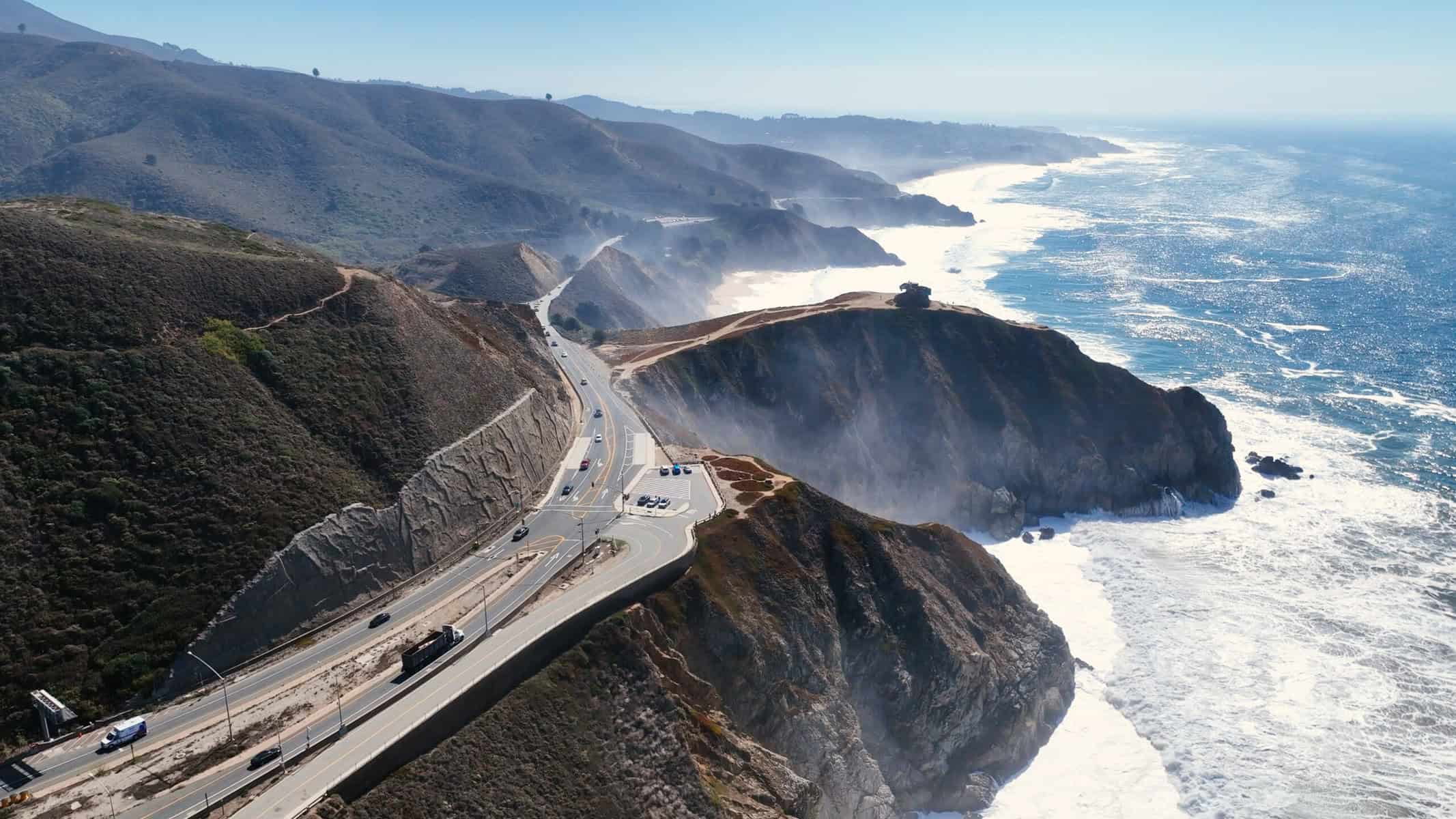
As a quick tip from me, driving from north to south is a much better experience on the Pacific Coast Highway. The views from the car and the easier ability to stop at vista points and turnouts without having to consider oncoming traffic makes the drive nicer, easier and more enjoyable.
Especially when it’s busy here in the summer months. And every vista point offers new, breathtaking views of the rugged coastline and the vast Pacific Ocean.

Garrapata State Park
Arriving at Garrapata State Park, we stop and walk down a short trail, which leads down a staircase to the beach, down to the beautiful Garrapata Beach.

As we hike along the trail, we enjoy fantastic views of the coast and the ocean. Nature is at its most impressive here. The trail ends at a wooden staircase that leads us directly down to the picturesque beach.

Once we arrive at Garrapata Beach, we linger for a while and marvel at the beauty of nature at Big Sur. Garrapata State Park, located along California State Route 1, is a hidden gem on the Monterey coast. The park offers a mix of rocky coastline, quiet beaches and trails with breathtaking views of the rugged coastal landscape and the Pacific Ocean.


Facts and figures:
- Size: 2,939 acres (approx. 1,189 hectares)
- Opened: 1983
- Location: Along Highway 1, 6.7 miles south of Rio Road in Carmel.
- Hours of operation: Daily from sunrise to sunset
- Special Features:
- 2 miles of coastline with beaches and rocky cliffs
- Diverse coastal vegetation and redwood groves
- Soberanes Point with prominent coastal headlands
- Popular spot for whale watching during the annual gray whale migration
- Various hiking trails, including the Soberanes Canyon Trail and the Rocky Ridge Trail
- Activities: Hiking, nature photography, bird watching, whale watching, beach activities
- Wildlife: Sea lions, seals, sea otters and various bird species
Official website: https://www.parks.ca.gov/?page_id=579
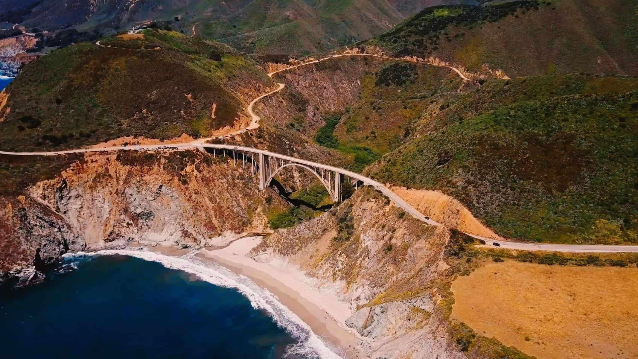
Rocky Creek Bridge
After a short break, we continue our journey. Our next highlight is the Rocky Creek Bridge, a masterpiece of engineering. This majestic reinforced concrete arch bridge, opened in 1932, is one of seven ‘Big Sur Arches’ along State Route 1.

At 152 meters long, it elegantly crosses Rocky Creek and offers some of the most picturesque views of the entire Big Sur coastline.
From the bridge, we have an unparalleled view of the rugged coastline. Steep cliffs rise up, while the deep blue waters of the Pacific stretch as far as the eye can see. It is particularly fascinating to watch the waves crashing relentlessly against the rocks – a spectacular spectacle of the forces of nature.

The Rocky Creek Bridge is more than just a connection; it is a symbol of human ingenuity in the midst of wild nature. Its curved lines seem to mimic the contours of the landscape, as if it had always been part of that environment.
Facts and figures:
- Opened: 1932
- Length: 152 meters (500 feet)
- Type: Reinforced concrete arch bridge
- Architect: John B. Leonard
- Special features:
- One of the seven ‘Big Sur Arches’ along State Route 1
- Offers spectacular views of the Big Sur coastline
- Important part of the historic California State Route 1
- Construction:
- Open spandrel arch design
- Utilizes reinforced concrete for increased durability in the harsh coastal environment
- Significance:
- Considered a significant example of 1930s bridge architecture
- Contributes to the picturesque character of the Big Sur coastal road
- Note for visitors:
- Be careful when stopping for photos as the road can be busy
- The best viewpoints are to the north and south of the bridge
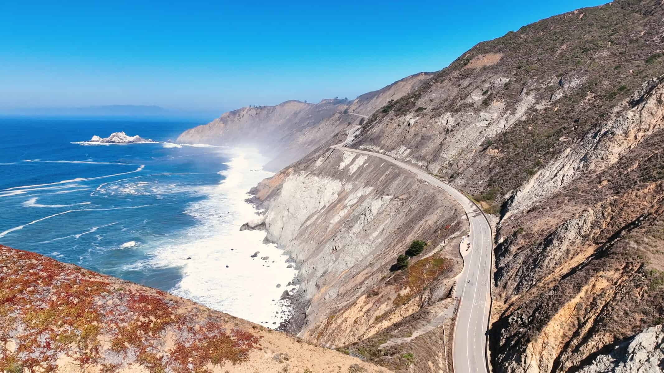
Bixby Creek Bridge
Just one kilometer further on, we reach the iconic Bixby Creek Bridge. This majestic structure is undoubtedly the landmark of Big Sur. Since 1932, it has spanned 218 meters and rises 79 meters above the roaring Pacific Ocean.

The Bixby Creek Bridge is not only an architectural masterpiece, but also symbolizes the development of the wild beauty of this region.
The most beautiful view of the bridge with the ocean in the background is from Coast Road, which leads into the Santa Lucia Mountains. From this vantage point, the full splendor of the bridge is revealed, embedded in the dramatic coastal landscape.

After marveling at the bridge for a long time, we continue our drive on the Pacific Coast Highway. Our next destination is perhaps the most beautiful beach on Big Sur, which we always had to skip on previous visits due to lack of time.
As we drive, the Santa Lucia Mountains become more and more prominent. This mountain range stretches along the coast and offers an impressive backdrop. The highest peak, Cone Peak, reaches an altitude of 1,570 meters and rewards hikers with a breathtaking view of the Pacific.

Of course, we don’t manage to simply drive through as planned. Every bend reveals new natural beauty and, as always, we stop at far too many viewpoints. Time is slowly running out, so we continue on to Pfeiffer Beach in a more targeted manner.

Facts and figures:
- Opened: 1932
- Length: 218 meters (714 feet)
- Height: 79 meters (260 feet) above sea level
- Type: Concrete arch bridge
- Architect: F.W. Panhorst
- Special features:
- One of the most photographed landmarks on the Pacific Coast
- Tallest single-arch concrete bridge in the world at the time of its completion
- Part of the National Register of Historic Places since 2000
- Construction:
- Open spandrel arch design
- Uses concrete instead of steel due to proximity to the coast and risk of corrosion
- Significance:
- Symbol for the development of the Big Sur region
- Important part of California State Route 1 (Pacific Coast Highway)
- Viewpoints:
- Best view from Old Coast Road
- Parking lots at both ends of the bridge for photo stops
- Note for visitors:
- Very popular tourist destination, often crowded, especially in the summer months
- Take care when taking photos, as the road is very busy
Santa Lucia Mountains:
- Highest peak: Cone Peak (1,570 meters)
- Length of the mountain range: about 170 km
- Part of the California Coast Ranges
- Known for:
- Diverse ecosystems, from coastal forests to alpine zones
- Home to rare plant and animal species
- Popular area for hikers and nature lovers
Pfeiffer Beach

Pfeiffer Beach is located in the heart of Big Sur, about 1.6 km from the Highway 1 turnoff. The access road, Sycamore Canyon Road, is narrow and winding. Large vehicles such as RVs are not permitted here. There is a parking lot just a few meters from the beach, the entrance fee during our visit was $15 per vehicle.


Pfeiffer Beach is known for its impressive rock formations, especially the famous Keyhole Rock. Under certain lighting conditions, the sun shines through it spectacularly – the so-called “Keyhole Arch Light Show” phenomenon. From late November to January, the setting sun creates an impressive beam of light through the hole in the rock.

Another unique feature is the purple-colored sand under certain weather conditions. This unusual coloration is caused by manganese-garnet deposits from the surrounding cliffs and is most visible after rainfall.
[foogallery id=”3170″]
Facts and figures:
- Location: Big Sur, California, about 1.6 km from Highway 1
- Access: Via the narrow Sycamore Canyon Road
- Parking fee: $15 per vehicle (as of 2024)
- Opening hours: Daily from sunrise to sunset
Special Features:
- Keyhole Rock: Famous rock formation with a natural arch
- “Keyhole Arch Light Show”: Spectacular light phenomenon, best visible from late November to January
- Purple sand: Caused by manganese-garnet deposits, especially visible after rainfall
Notes for visitors:
- Large vehicles such as RVs are not permitted on the access road
- The beach can be partially flooded at high tide
- Swimming is not recommended due to strong currents
- Dogs are allowed on a leash
Best time to visit:
- For the “Light Show”: December to January
- For fewer visitors: Weekdays outside the vacation periods
- For purple sand: After rainfall
Official website: https://www.fs.usda.gov/recarea/lpnf/recarea/?recid=10918
Julia Pfeiffer Burns State Park McWay Falls
We continue our drive on the scenic Highway 1 and reach Julia Pfeiffer Burns State Park, home of the famous McWay Falls. This 24-metre-high waterfall plunges directly onto the beach and offers a postcard motif that is second to none.

McWay Falls can be reached via the Overlook Trail, which is about 0.8 kilometers long. A small viewing platform offers a picturesque view of McWay Cove. At high tide, the waterfall becomes a tidal fall that flows directly into the sea. There are only two of these unique waterfalls in California and only five in the entire USA.

Parking is available at Julia Pfeiffer Burns State Park just across the road for a $10 fee, or along Highway 1, where parking is free but very limited. A short trail leads through a tunnel under Highway 1 to the overlook.
[foogallery id=”3172″]
Facts and figures about Julia Pfeiffer Burns State Park and McWay Falls:
Julia Pfeiffer Burns State Park:
- Location: 52801 California State Route 1, Big Sur, CA 93920
- Size: 3,762 acres (approx. 1,522 hectares)
- Park fee: $10 per vehicle
McWay Falls:
- Height: 80 feet (24 meters)
- Special feature: One of only two tidefalls in California and five in the U.S
- Year-round waterfall
Overlook Trail:
- Length: approx. 0.6 miles (0.8 km) loop trail
- Accessibility: Wheelchair accessible
- Viewpoint: Offers panoramic views of McWay Falls and the Pacific Ocean
Important notes for visitors:
- The park is very popular and often crowded. Early arrival is recommended.
- No beach access or access to the waterfall allowed
- Dogs are only allowed on paved areas, not on hiking trails
- Best time for whale watching: December, January, March and April
Other attractions:
- Ancient redwood trees (up to 2,500 years old and 300 feet tall)
- Various hiking trails of different levels of difficulty
- Pelton Wheel exhibit along the Overlook Trail
Official website: https://www.parks.ca.gov/?page_id=578
San Simeon with the Hearst Castle

Our last stop at the southern end of the Big Sur is San Simeon, known for the magnificent Hearst Castle. This imposing estate, built by media mogul William Randolph Hearst, is a testament to the opulent lifestyle of the 1920s and 1930s. Guided tours of the castle offer fascinating insights into the history and architecture of this unique place.
Hearst Castle: a dream of marble and gold
Perched high above the Pacific Ocean, Hearst Castle looks like a fairytale castle from another era. Built between 1919 and 1947 for the newspaper magnate William Randolph Hearst, it is now one of the most visited museums in California.

Even the journey to the castle is an experience. The shuttle bus takes you up the winding road, past pastures where descendants of the former zoo inhabitants still graze today. Once you reach the top, you have a breathtaking view over the coast.
The castle itself is an architectural masterpiece. Designed by architect Julia Morgan, it combines various European architectural styles to create a unique work of art. 165 rooms, including 38 bedrooms and 41 bathrooms, are spread across the extensive estate.

Art treasures and luxury
Inside, visitors can expect a wealth of art treasures and luxurious furnishings. Antique statues, precious paintings and handcrafted furniture bear witness to the exquisite taste of the master of the house. Particularly impressive are the sumptuous dining room and the cozy cinema, where Hearst enjoyed the latest Hollywood films with his prominent guests.

Gorgeous gardens and pools

The grounds are in no way inferior to the castle. Extensive gardens with Mediterranean vegetation surround the estate. The absolute highlight are the two spectacular swimming pools:
- The Neptune Pool: a dream in blue and gold, surrounded by ancient columns and statues. On sunny days, the sky is reflected in its crystal-clear water.
- The Roman Pool: A work of art made of mosaic tiles, inspired by Roman baths. The golden decorations and blue tiles create a magical atmosphere.

Practical information for your visit
- Various tours are available, from the one-hour introductory tour to specialized themed tours.
- Prices start at around $30 for adults and $15 for children.
- Reservations are strongly recommended, especially in high season.
- The visitor center at the base of the hill offers a museum, movie theater and restaurants.
Elephant Seal Vista Point in San Simeon
The Elephant Seal Vista Point, also known as the Piedras Blancas Elephant Seal Rookery, is a unique natural spectacle on the coast of San Simeon, California. Here, visitors can observe elephant seals in their natural habitat all year round. It is a beautiful sight to see these animals here in the wild.


Important facts:
- Location: About 7.2 km north of San Simeon on California State Route 1
- Admission: Free and open daily
- Best times to visit: December to March (mating season and birth of young) and April to August (moulting season)
Special features:
- The only freely accessible elephant seal colony in the world
- Up to 17,000 elephant seals per year
- Observation platforms and information boards along the coast
- Volunteer nature guides (Friends of the Elephant Seal) on site
Rules of conduct:
- Keep a minimum distance of 25 meters from the animals
- Do not feed or disturb the animals
- Keep dogs on a lead
Interesting facts:
- Male elephant seals can weigh up to 2,300 kg and grow to 4.5 m long
- Elephant seals can stay under water for up to 2 hours
- The population has recovered from near extinction to over 150,000 animals
Visitor facilities:
- Large parking lot directly on the coastal road
- Information center in San Simeon with exhibition and souvenir store
That’s it: the most breathtaking sights and unforgettable places along the legendary Big Sur. This stretch of the famous Pacific Coast Highway made a deep impression on us with its raw natural power and unbridled beauty. Big Sur is a place that touches all the senses and inspires the spirit. Its majestic cliffs, endless views of the Pacific Ocean and ancient redwood forests never cease to fascinate us.
If you liked the video, give me a thumbs up and subscribe to my channel. Let me know in the comments which are your favorite places in California or which you still want to discover. Until the next movie and thanks for reading and watching!
Your Alex
Hits: 423